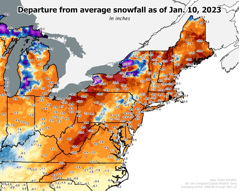
While snow continues to pile up in the West, there are no clear signs that the East will see any snowier weather in the near future.
Many cities are approaching record late prime accumulation
Several cities along the East Coast are nearing their final starts to the snow season on record due to a lack of measurable snow:
- New York: This winter is the ninth longest without measurable snow. Its last first measurable snow is on January 29th.
- Philadelphia: This winter is the 12th longest without measurable snow. Its last first measurable snowfall is on February 3, although no snow fell in the winter of 1972-73.
- Atlantic City: This winter is the 13th longest without measurable snow. Its last first measurable snow is on February 16th.
- Baltimore: This winter is the 11th longest without measurable snow. Its last first measurable snow is on February 21st.
- Washington: This winter is the 16th longest without measurable snow. Its last first measurable snow is on February 23rd.
In New York and Philadelphia, the first accumulated snowfall of the winter is now more than a month later than average. In Washington, it's more than two weeks late.
Average first accumulated snowfall has drifted later in the calendar year over time across much of the coastal Northeast due to climate change and urbanization.
Snow is also in short supply in New England. Boston has gotten a paltry 1.2 inches. That's about 13.5 inches below average. In Portland, Maine, 6.8 inches so far compares to an average of 22.6 inches.
Snow in the interior northeast is also down
In many lower snow winters, one can still head into the mountains to find powder. Not so much this season.
Lest one think the bounty of snow around Buffalo — where a violent blizzard hit on Christmas — is widespread, consider that nearby Syracuse has received only 20.1 inches compared to an average of 49.8 through 10 January. Similarly, only 9.3 inches have fallen in Rochester compared to an average of 36.7 inches so far.
In Burlington, Vt., only 17.5 inches have fallen compared to an average of 32.6 inches for the day. In the mountains northeast of Burlington, snow totals this season are generally 2 feet or more below average, including Mount Mansfield whose snow depth is flirting with the lowest on record.
At Mount Washington, NH, in the White Mountains, the 73.6 inches of snow so far is 43.6 inches below average.
The snow drought continues as one travels south through the Appalachians.
The coldest and snowiest parts of the Mid-Atlantic have seen historically low snowfall so far. In Canaan Valley, one of the coldest and snowiest areas of West Virginia, amounts are about 42 inches below average for the day. Elkins, W.Va., has only recorded 3.8 inches so far, compared to an average of 24.8 inches.
Similarly, peaks along the border of North Carolina and Tennessee are about a foot and a half below average.
Huge opposition from the West
The West Coast steals much of the East Coast's snow as a parade of storms pound California. Since the West is so dependent on this snow for its water resources, several feet of accumulation in the Sierra Nevada and nearby mountains is generally good news.
Some of the higher peaks in the Sierra have seen totals of 200 to 250 or more inches above average so far, or already close to typical totals for an entire winter. Mammoth Mountain in the eastern Sierra reported 310 inches Tuesday morning, compared to the seasonal average of 400 inches, with heavy snow still falling.
Since jet streams tend to be wavy, if there is a dip in the West, which helps attract storms from the ocean, there will often be a bump in the East, which deflects the storms away.
Future pattern change to increase snow chances?
The chances of a cold and snowy pattern developing in the Northeast US are not great for the next one to two weeks. But because it's the middle of winter when temperatures are generally colder, snow can sometimes develop in a short period of time – even in a mild pattern.
The pattern could become more favorable for snow in the East starting around January 20th. That's when the jet stream pattern can reverse — blocking the stormy attack in the West and allowing cold air to return to the East.
However, the strong jet stream in the West can be difficult to break up, so computer models touting this pattern change may be wrong.
Snow lovers are advised to head West for reliable snow until further notice.


